
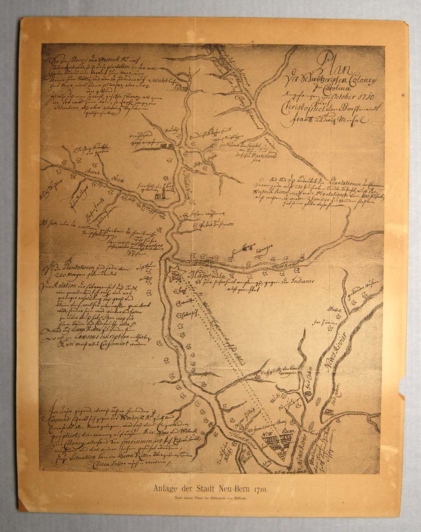
Graffenried. Plan der Schwytzerischen Coloney in Carolina, angefangen im October 1710
| Accession Number | TP.1958.029.002 |
|
Title |
Plan: “Plan der Schwytzerischen Coloney in Carolina, angefangen im October 1710” (Plan of the Swiss colony in Carolina begun in 1710).
|
|
Maker |
Artist/ cartographer: Christophe von Graffenried Engraver: None Printer/ publisher: None
|
|
Material |
Photostat of drawing
|
|
Origin |
[Switzerland, Bern]
|
|
Date: |
[1716]
|
|
Dimensions: |
Paper: 19 ¾” X 15 3/8” Plate: none Image: 17” X 13 5/8”
|
|
Description: |
Photostatic copy of a hand-drawn map of
the New Bern area by Christophe von
Graffenried. Plan der Schwytzerischen Coloney in Carolina, angefangen im
October 1710 durch Christophel von Graffenriedt und Frantz Ludwig Michel
[title] | Anlage der Stadt Neu-Bern 1710 Nach einem Plane der Bibliothek
von Mülinen [printed title below]
|
|
Source: |
Gift
|
|
Relation: |
|
|
Comments: |
Photostatic copy of manuscript map mounted on artist’s board. Plan of the Neuse and Trent Rivers from their confluence towards their sources, with the location and occasional identification of homes on their banks. In 1914, the German-American Historical Society at Philadelphia published the map, together with a French version of von Graffenried’s account of the Swiss settlement at New Bern. Last located in a private collection in Bern, Switzerland at the end of World War II, the original map is currently located in the Burgerbibliothek Bern: Mss.Mül.466 (3a).
|
|
Language: |
German
|
|
Map Image: Click on an area of the image at the right to view a larger image of that area. Or Click here for an enlargement of the entire map (142189 bytes).
|
 |
Images scanned by Dean Knight
Text prepared by Nancy Richards and Victor T. Jones, Jr.
This project is supported with federal LSTA funds made possible through a grant from the Institute of Museum and Library Services, administered by the State Library of North Carolina, a division of the Department of Cultural Resources through the North Carolina ECHO, 'Exploring Cultural Heritage Online' Digitization Grant Program.


![]()

Copyright © 2009-2015, New Bern-Craven County Public Library. All Rights Reserved.