
Unknown. A New Description of Carolina (1676)
| Accession Number |
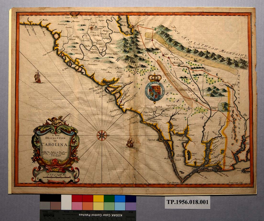
TP.1956.018.001
|
|
Title |
Map: “A New Description of Carolina”
|
|
Maker |
Artist/ cartographer: Unknown Engraver: Francis Lamb Printer/ publisher: Unknown Sellers: Thomas Bassett and Richard Chiswell
|
|
Material |
Laid paper, ink, watercolor
|
|
Origin |
England, London
|
|
Date: |
1676
|
|
Dimensions: |
Paper: 15 5/8” X 20 3/8” Plate: 15 1/8” X 20 1/8” Image: 14 7/8” X 19 7/8”
|
|
Description: |
Hand-colored, engraved map: “A New Description of Carolina. Sold by Tho: Bassett in Fleetstreet. And Ric: Chiswell in St Paul Churchyard. [cartouche, bottom left] | Francis Lamb, sculp. 1676 [inside neat line, bottom right]
|
|
Source: |
Purchase
|
|
Relation: |
The map depicts Carolina from the coast to the Appalachian Mountains. It is based on John Ogilby’s 1672 map of the area and includes information on the interior of the province taken from John Lederer’s map of the same year, which purported to show the topography of the interior in the regions from the falls in the James River (in Virginia) westward to the Virginia Blue Ridge Mountains and southwest to the Carolina piedmont. The map appeared in an addendum to the 1767 edition of The Theatre of the Empire of Great Britain entitled “A Prospect of the Most Famous Parts of the World.”
|
|
Comments: |
|
|
Language: |
En
|
|
Rights: |
Permission to use the photograph must be obtained in writing from Tryon Palace Historic Sites & Gardens, New Bern, North Carolina. It must be accompanied by the caption” From the collection of Tryon Palace Historic Sites & Gardens, New Bern, North Carolina; North Carolina Department of Cultural Resources, Division of Archive and History.” |
|
Map Image: Click on an image at the right to enlarge that image. |
  |
Images scanned by Dean Knight
Text prepared by Nancy Richards and Victor T. Jones, Jr.
Last edited: August 21, 2018
This project is supported with federal LSTA funds made possible through a grant from the Institute of Museum and Library Services, administered by the State Library of North Carolina, a division of the Department of Cultural Resources through the North Carolina ECHO, 'Exploring Cultural Heritage Online' Digitization Grant Program.


![]()

Copyright © 2009-2015, New Bern-Craven County Public Library. All Rights Reserved.