
Collet. A Compleat Map of North Carolina (1770)
| Accession Number | TP.1956.014.001 |
|
Title |
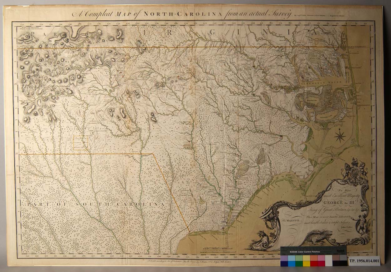
Map: “A Compleat Map of North Carolina from an actual survey”
|
|
Maker |
Artist/ cartographer: Capt John Collet Engraver: I Bayly Printer/ publisher: S. Hooper
|
|
Material |
Laid paper, ink, watercolor
|
|
Origin |
England, London
|
|
Date: |
1770
|
|
Dimensions: |
Paper: 31 1/8” X 45 3/8” Plate: 30 ½”X 44 ¼” Image: 28 3/8” X 44 5/16” . |
|
Description: |
Hand-colored, engraved map made of two joined sheets: A Compleat Map of North Carolina from an actual Survey. By Captn Collet, Governor of Fort Johnston. Engraved by I. Bayly. [across top of map, above neat line] | To His Most Excellent Majesty George the IIId King of Great Britain, &c, &c, &c, This Map is most humbly dedicated by His Majesty’s most humble obedient & dutiful Subject John Collet [cartouche, bottom right] | Publish’d according to Act of Parliament, May the Ist 1770, by S. Hooper. No. 25 Ludgate Hill, London. [below neat line, center] | Watermark: “J Whatman.”
|
|
Source: |
Purchase
|
|
Relation: |
The Collet map includes all of North Carolina from the coast westward to “Table [Rock] Mountain, near the present site of Morganton. It illustrates the western movement of population to and across the Piedmont during the middle of the eighteenth century. One of the finest provincial maps, it surpasses any previous map of the region in scope and accuracy. Henry Mouzon used it as the model for the northern half of his map of North and South Carolina (TP.1956.005.001). It is the basis for many subsequent maps of North Carolina from its appearance in 1770 until the Price-Strother map of 1808.
|
|
Comments: |
Born in Switzerland, John Abraham Collet (fl. 1756-1789) came to America in 1767 under the auspices of the British crown to serve as governor of Fort Johnston near Wilmington, North Carolina. In 1768 he served as aid-de-camp to Governor William Tryon in his Hillsborough expedition against the Regulators. Collet’s map is unusual in including a great deal of topographical detail. Although he did little of the surveying himself, Collet had the advantage of access to earlier surveys taken by William Churton under the aegis of the royal governors especially Royal Governor William Tryon. The remarkable asymmetrical cartouche in the lower right corner contains a dedication to George III. Surmounted by the Hanoverian crest, it contains symbols of the new world including an Indian, an alligator and a wildcat. Relatively few copies of this map have survived. In 1959 only a dozen copies were known. Several important sites are highlighted on the map including New Bern, the site of the new capitol, and the “Gov. H[ouse] Bellefont” at Brunswick-town.
|
|
Language: |
En
|
|
Rights: |
Permission to use the photograph must be obtained in writing from Tryon Palace Historic Sites & Gardens, New Bern, North Carolina. It must be accompanied by the caption” From the collection of Tryon Palace Historic Sites & Gardens, New Bern, North Carolina; North Carolina Department of Cultural Resources, Division of Archive and History.” |
|
Map Image: Click on an area of the image to the right to view a larger image of that area. |
 |
Images scanned by Dean Knight
Text prepared by Nancy Richards and Victor T. Jones, Jr.
Last edited: August 21, 2018
This project is supported with federal LSTA funds made possible through a grant from the Institute of Museum and Library Services, administered by the State Library of North Carolina, a division of the Department of Cultural Resources through the North Carolina ECHO, 'Exploring Cultural Heritage Online' Digitization Grant Program.


![]()

Copyright © 2009-2015, New Bern-Craven County Public Library. All Rights Reserved.