
Mouzon. An Accurate Map of North and South Carolina (1775)
| Accession Number |
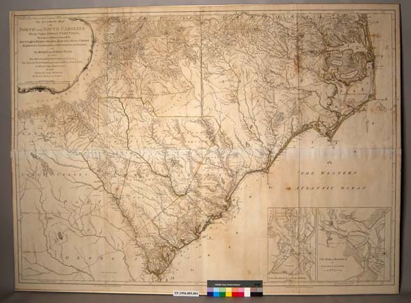
TP.1956.005.001
|
|
Title |
Map: “An Accurate Map of North and South Carolina, with their Indian Frontiers”
|
|
Maker |
Artist/ cartographer: Henry Mouzon, Jr. and others [Ephriam Mitchell] Engraver: Sparrow Printer/ publisher: Robert Sayer and J. Bennett
|
|
Material |
Laid paper, ink
|
|
Origin |
England, London
|
|
Date: |
1775
|
|
Dimensions: |
Paper: 41 ¾” X 56 ¾” Plate: 40 13/16” X [not visible] Image: 39 15/16” X 55 ½” Insets: 1. “The Harbour of Port Royal” Size: 10 ¾” X 6 15/16” 2. “The Bar and Harbour of Charlestown” Size: 10 ¾” X 10 ½”
|
|
Description: |
Engraved map made of eight joined sheets: An Accurate Map of North and South Carolina with their Indian Frontiers, Shewing in a distinct manner all the Mountains, Rivers, Swamps, Marshes, Bays, Creeks, Harbours, Sandbanks and Soundings on the Coasts; with The Roads and Indian Paths; as well as The Boundary or Provincial Lines, The Several Townships and other divisions of the Land In Both the Provinces; the whole from Actual Surveys By Henry Mouzon and Others. London Printed for Robt Sayer and J. Bennett, Map and Print-sellers, No 53 in Fleet Street. Publish’d as the Act directs May 30th 1775. [cartouche, top left] | Sparrow Sc. [below cartouche] | Publish’d as the Act directs May 30th 1775. by R. Sayer and J. Bennett [below neat line, left center] | Publish’d as the Act directs May 30th 1775. by R. Sayer and J. Bennett [below neat line, right center]. | Insets: “The Harbour of Port Royal” and “The Bar and Harbour of Charlestown
|
|
Source: |
Purchase
|
|
Relation: |
This map extends from the coastal area of the two Carolinas westward to the Appalachian Mountains, Cherokee territory, upper Creek territory and part of Georgia. It was the first map of the Carolinas issued during the Revolutionary War period and was used by British, French and American forces. It remained the chief of map for the region during the forty or fifty years following its publication. Thomas Jefferys included the Mouzon map in The American Atlas (London, 1775). George L. Le Rouge published a French edition of the Mouzon map in Atlas Amèriquain Sepentrionale (Paris, 1777). That version is titled in French and English and includes an inset of the English attack on Fort Sullivan (June 28, 1776). A third version of the map was issued in 1794 by Laurie and Whittle, successors to Sayer and Bennett, using the original plates.
|
|
Comments: |
Mapmaker and civil engineer, Henry Mouzon, Jr. (1741-1807) was the grandson of a Huguenot immigrant to South Carolina who held land grants in Berkeley County. Henry, Jr. was born in Craven (now Williamsburg) County, South Carolina. After his father’s death in 1749, eight-year-old Henry Jr. was sent to France for his education, where it is presumed that he learned mapmaking skills. He received his first important public commission in 1771, when he and Ephraim Mitchell (subsequently the surveyor general of South Carolina) were appointed by Governor Lord Charles Greville Montague to survey the boundaries of the civil districts of South Carolina. In May 1774, Mouzon advertised a proposal for a corrected map of South Carolina to be issued the following January. When the map was published, it included both North and South Carolina and corrected some of the mistakes of the two previous maps of the area—James Cook’s 1773 map of South Carolina and John Colett’s 1770 map of North Carolina. Individual copies of the map cost £5. A few pocket maps on parchment, priced at $1, were available “for the use of Gentlemen who ride the circuits and others who travel.”
|
|
Language: |
En
|
|
Rights: |
Permission to use the photograph must be obtained in writing from Tryon Palace Historic Sites & Gardens, New Bern, North Carolina. It must be accompanied by the caption” From the collection of Tryon Palace Historic Sites & Gardens, New Bern, North Carolina; North Carolina Department of Cultural Resources, Division of Archive and History.” |
|
Map Image: Click on an area of the image to the right to view a larger image of that area. |
 |
Images scanned by Dean Knight
Text prepared by Nancy Richards and Victor T. Jones, Jr.
Last edited: August 21, 2018
This project is supported with federal LSTA funds made possible through a grant from the Institute of Museum and Library Services, administered by the State Library of North Carolina, a division of the Department of Cultural Resources through the North Carolina ECHO, 'Exploring Cultural Heritage Online' Digitization Grant Program.


![]()

Copyright © 2009-2015, New Bern-Craven County Public Library. All Rights Reserved.